N'dakina - Our Homelands
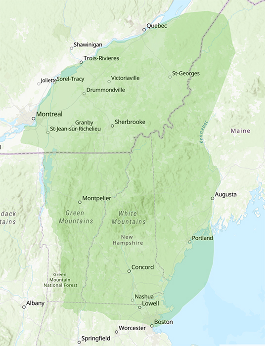
The following is a detailed description of N'dakinna, our homeland. It includes all lands, waters, the air, and other natural resources that our ancestors of the above named groups lived, fished, hunted, trapped, planted, farmed, and harvested from Mother Earth's natural bounty. In colonial times N'dakinna covered all of New France and the colonial Commonwealth of Massachusetts. This area is now known as the province of Quebec in Canada, and the states of Maine, New Hampshire, Vermont, New York, and Massachusetts in the United States.
It should be noted that the greater Abenaki Nation did not relinquish any portion of our homeland as a result of any land lease, deed, grant, taking, treaty, or agreement executed by any Abenaki individuals or families, and does not recognize any agreements that have been used to occupy our homeland. There are no known legitimate or lawful agreements that were executed by or "on-the-behalf-of" the greater Abenaki Nation, Abenaki Bands, Abenaki families, or Abenaki People from the time of creation to present day. Any land related agreements that were executed in Canada or the United States, after their national sovereign status was declared, were done so without the full authority or recognition of the greater Abenaki Nation and Abenaki People that were resident on both sides of the Canadian-United States political border. At the time that any such lease, deed, grant, taking, or agreement may have been created, they were done so in violation of existing laws and regulations of authority and the representative parties were not authorized to enter into such agreements on the behalf of the greater Abenaki Nation, Abenaki Bands, Abenaki families, Abenaki People, or the occupying governments of the time.
The following describes the boundaries of N'dakinna by way of the rivers, lakes, landmarks, and the meeting points with the other First Nations People that border N'dakinna. The primary descriptions and bounds of N'dakinna are identified in the Aln8bad8wa (Abenaki) language.
Starting at a northwest location - Nsawiwi pebonkik ta ali-nkihl8t (northwest from) where the Chateauguay River and the Ktsitegok (great river) - Moliantegw (St. Lawrence River) meet near Molian (Montreal). The Os8ganek (Algonquin place) is the point where the lands of the Abenaki (N'dakinna), Algonkin, and Mohawk nations (Magwak) meet.
Waji nahil8t (going easterly) along the Ktsiegok (great river) Moliantegw (St. Lawrence River), past the Bitawbagwizibok (Richelieu River), past the Wigw8madenik (Yamaska River) and the village of both the Abenaki and Mohawk lived, past Masessolina (Sorel), past Pithiiganek (Nicolet) and the Pithiganitegw (Nicolet River), past Mad8balodnik and the village of Mad8balodniak (Three Rivers).
Continuing, Ali-nkihlot (easterly) past the Alsog8ntegok (St. Francis River) and Welinaktegw or W8linaktegw (the river which has long turns - which causes delay by its windings) (Becancour River) upon which Abenaki villages of Odanak and W8linack (Wolinak) are still occupied by the Abenaki People.
Continuing, Ali-nkihlot (easterly) along the Ktsiegok (great river) Moliantegw (great river) (St. Lawrence River) to the Kik8ntegok (river of fields) (Chaudiere River) upon which the Abenaki villages of St. Joseph de Collraine and Kwanah8moik (long point in the river bend) (Durham) and other Abenaki villages along the Koattegok or Koattegw (pine river) (Coaticook River), Namaskonkik (fish field) (Megantic Lake) were settled.
Continuing, Ali-nkihlot (easterly) beyond the Etchemin River (sand berries) and up to Kebek (Quebec) and the Isle de Orleans at the point that the Abenaki and Ksitegwiiak (the land of the Hurons) meet near the village of Pamadenainak (Lorette), up to the village of O'bamasisek (Yamachiche).
Going inland to the Big Black River to the point that it joins the St. John River at the Notre Dame Mountains the point where the Abenaki meet the Moskwas (muskrat - Malecite - Maliseet - broken talker). Across the St. John River and along the the lands of the Malecite (Maliseet, Wulastegniak, Aroostook, St. John's - good river people) and further east to the land of the Passamaquody (Machias, Opanango, Pesmokant, Quoddy, Scotucks, Unchechauge, Unquechauge, St. Croix - plenty of pollock / pollock spearing place).
Sowanakik, (going southward) through the watersheds of the Allagash River, the Musquacook Lakes, the Chemquasabamticook Lake, the Churchhill Lake, the Chamberlain Lakes, the Caucomgomoc Lake, the Baker River, the Baker Lake, the Seboomook Lake, the Chesuncook Lake, the Moz8debinebesek (Moosehead Lake), and to the Kenebec (Kennebec River) and through Kwen8bagok (long lake - Kennebago Lake).
The Kenebec (deep river - Kennebec River) being the boundary where the Abenaki meet the Pan8bskaik (land of the Penobscot) Pana8bskaiiak (Penobscot Pentagoet, Panaomeska - plenty stones / rocky place / ledge place).
Going down stream the Kenebec (Kennebec River), past the ancient Abenaki village of Mol8joak (deep flow river) (Norridgewock) and continuing to the Sobagwa (great ocean - Atlantic Ocean). The Abenaki villages on the Laesikantgw (rock shelter river - Androscoggin River) are the villages of Amescana and Narakamik.
Sowanakik (going southerly) along the coast of the Sobagwa (Atlantic Ocean), past W8linak (village on the bay - village of Wwenock), past Kaska, past Pejepskw (bad rock - Pejepscot), past the Laesikantegw (Androsooggin River), past the Presumpscot River, past Sokwakik (Saco) and the Zawakwtegok (Saco River), past Kinib8ka (rough ground) (Kennebunk), past the M'mosem (my moose river - Mousam River), past Ogwa8mkwik (at the accumulated sand - Ogunquit), past the village of Piscataqua on (great deer river) Pesgatakwa (dark river - Piscataqua River), to the outlet of the Mol8demak (deep river - Merrimack River) at the Sobagwa (Atlantic Ocean).
The Mol8demak leads to the Pemijewasek (Pemigewasset River) and to the lake of Wiwinebesaki (land around the lake - Lake Winnepisaukee), the Abenaki villages of this area are Wiwinebesakik land around the lake place - Winnepisaukee Village), Akwadocta, Asepihtegw (river alongside - Ossippee), and Apikwehkik). The Abenaki villages on the Mol8demak are the villages of (Wamesit (fishing place), Nanaskik (place of fish - Manchester), Penokok (down hill - Concord), and Senikok (at the rocks - Suncook), Wiwinijoanek (water flows around it - Dover).
The other area lakes and waters are: Massabeskik (large lake - Massabesikick Pond), N8wijoanek (long rapids - Salmon Fall River), Seninebik (rocky lake - Lake Sunapee), and W8bagok (clear lake - Lake Umbagog).
Ali-ali-nkihl8t (westward) along the Mol8demak (Merrimack River) past the village of Wamesit to the Pagontegok (Concord River), a one day's walk from the eastern shores of the Mol8demak (Merrimack) and Concord Rivers lands of the Pawtucket (Agawam, Naumkeag, Saugus, Winnisinet) to the lands of the Msajosek (the great hill) (Massachuset Nation), Neponsit (Massachusett) and Shawmut (Massachusett), to the headwaters of the Concord, Sudbury, Assabet, and Nashua Rivers lands of the Nsawiwi (between the rivers) (Nashua) (Nashaway, Washoc, and Nashoba) to the area known as the Narragansett corridor along the Blackstone River and lands of the Nipmuc (Nipmuck) People.
Ali-ali-nkihl8t (westward) to Wachuset (mountain of small / middle height - Mt. Wachuset) at the Warre River the meeting place of the Nipmuc and Abenaki.
Ali-ali-nkihl8t (westward) to Millers River, west to the Pokw8mtegok (very narrow river) (Pocumtuck River) and the land of the Pocumtuc.
Ali-nkihl8t (westward) crossing the Kwinitegok (long river - Connecticut River). The Abenaki villages along the Kwinitegok are the villages of Sokwakik (southern place - Squakeag), Ktispontegok (great falls - Bellows Falls, Vermont), Goasek (place of pines - Newbury and Wells River, Vermont and Woodsville and Haverhill, New Hampshire).
The rivers that feed the Kwinitegok are the 8manosek (fishing place - Ammonoosuc River), the Pasomkasik - Pemijoaswek (swift current - Pemigewasset River), and the Goategok (pine river - Coaticook River) (upper Connecticut valley).
The other lakes, rivers, and waters of N'dakinna are the Menahanbagok, (island pond - Island Lake), Mamhiawbagok (wide water - Lake Mephramagog), Wasabastegok, Sobagwa (ocean - Sebago Lake), Nebiz8nnibizik (little medicine water - Alburg Springs), Mikazawitegok (black river - Black River), Bonsawinno (fire keeper - Lake Bomoseen), Pibesgantegok (roily river - Dead Creek), Nebiz8nnibik (medicine water - Highgate Springs), Massawippi (clear water - Holland Pond), Kwenosakek (pike place - mouth of Lamoille River), Kwenaskategok (long point river - La Platte River), Tamakwa (beaver - Maquam Bay), Masipskiwibi (flint water - Missisquoi Bay), Klahigantegok (wooden trap river - Nulhegan River), Pas8mkasik (clear sandy river - Passumpsic River), Kwenozasek (at the pike place - Pike River), and Wasabastegok (clear stream - White River).
Continuing, Ali-nkihl8t (westward) crossing the Kwinitegok to the Deerfield River and the lands of the Mahiganek (at the Mahigans) Mahican Nation.
Continuing, Pebonkik (northward) to Onegigwizibok (Otter River - Otter Creek). The lands of the Green Mountains and Onegigwizibok (Otter Creek) and the lands beyond Lake George to the western lands (Wawobzdenik, Senapskaizibok, and the lands of Ganienkeh) to the west of Bitawbagok (lake between - Lake Champlain) are the Wawobadenik (white mountains - Adirondack lands and mountains) between the N'dakinna (Abenaki) and Magwak (Mohawk) nations.
The Abenaki villages on Bitawbagok are the villages of Winoskik (onion place - Winooski), Mskitegwa (quiet water - Milton, Vermont), and Mazipskaik (flint place - Swanton, Vermont), and on the river Onegigwizibok is the village of Natami pontegok (first falls - Vergennes, Vermont).
The rivers that feed the Bitawbagok are the Wazowategok (crooked river - Missisquoi River), the Wintegok (marrow river - Lamoille River), the Winoskitegok (onion river - Winooski River), the Seniganitegok (stone works river - Lewis Creek), and the Onegigwizibok (Otter River - Otter Creek).
Continuing, Pebonkik (northward) up through the Bitawbagok (Lake Champlain) and all of its shores going north and west through the water sheds of the Chateuaguay and Bitawbagwizibok (Richelieu) Rivers back to the Ktsitegwiiak (St. Lawrence River).
The major mountains of N'dakinna are: Gawasiwajo (windfall mountain - Mt. Kearsage), G8dagwjo (hidden mountain - Mt. Washington), Menonadenak (stands alone mountain - Mt. Monadnock), Wawobadenik (White Mountains or Adirondack Mountains), Pemapskadena (rocky mountain - Mt. Ascutney), Mozeodebe wadso (moose head mountain - Mt. Mansfield), Mateguasaden (rabbit mountain - Mt. Philo), Pisgag (dark - Mt. Pisga) and Wachuset (mountain of small / middle height - Mt. Wachuset), Dowabodiwadjo (saddle mountain - Camel's Hump), Mozal8mo (calls like a moose - Mt. Moosalamoo), and Mozalhlakik (cow moose land - Mt. Mooselauke).
This describes the Abenaki homeland, N'dakinna bordered by the Magwak (Mohawk) to the west, the Ksitegwiiak (the land of the Hurons) and Osoganek (Algonquin Place) to the north, the Moskwas (Malecite-Maliseet), Mikm8z (Micmac), (Passaamakwadi) Passamaquoddy, and Pan8bskaik (Penobscot) to the east, the Massacusett and Nipmuc to the south, and the Mahiganek (Mahican) to the west. This describes the N'dakinna that the Abenaki People declare to be our sovereign homeland.
Cowasuck Band of the Pennacook - Abenaki People
Alton, New Hampshire 03809-0052
Phone: 603-776-1090
Email: cowasuckpwp@gmail.com